

 Fancy a new hiking outfit? Use the discount code "Eli" to save at least 10% on your order at Bergmensch! 🤩 Don’t miss out – take advantage of this offer now:
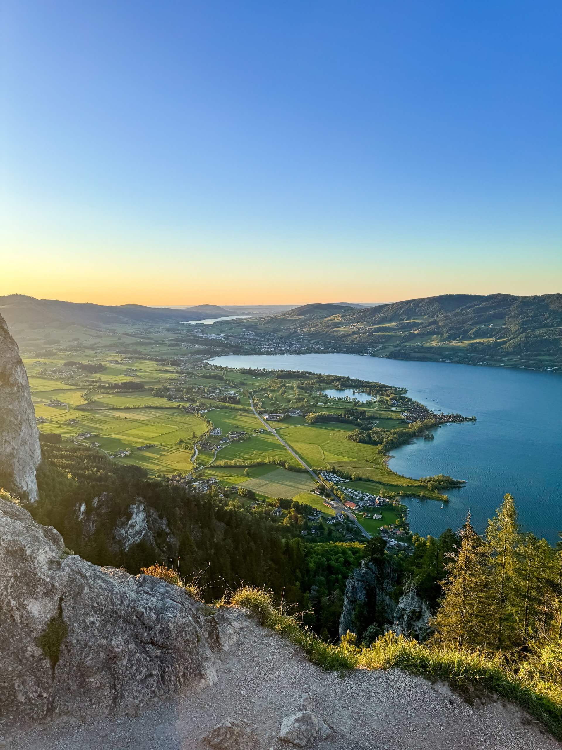
The hike to the Almkogel offers magnificent views of the Salzkammergut. The views of the Drachenwand, Schafberg, Mondsee and Attersee are particularly impressive. The sunset on the descent is a particular highlight.
The hike to the Almkogel, located between Mondsee and St. Gilgen in the beautiful Salzkammergut region, is an ideal tour for in-between. It is particularly charming in the evening, when the sun slowly sinks behind the mountains and transforms the sky into a colourful spectacle. The fantastic view of the surrounding lakes and mountains from the summit makes this hike an unforgettable experience.

Be sure to check out my reel for this tour:
Check out this post on Instagram
Directions and parking options for the hike to the Almkogel
The journey to the Almkogel is uncomplicated and easy to reach. If you are coming from Salzburg, take the Mondsee motorway exit. Coming from Linz, take the Oberwang exit. Then drive towards St. Gilgen until you pass Lake Krottensee. You can then park conveniently right next to the Krottensee, where there is a gravel car park, which is also the starting point for the hike. Travelling by public transport was out of the question for me this time, as I was out and about with my dog Shaggy.
Check out public transport right here:

The hike up the Almkogel: an evening adventure in the Salzkammergut
We started our hike at around 7.00 pm and set off at a good pace. The start was right at the car park at Krottensee, with a steep climb waiting for us right at the beginning. The first 500 metres were a real challenge with 100 metres of elevation gain. The trail initially led along a forest path before turning into a forest road in places. Along the way, there were always fantastic views of Lake Mondsee, which almost made us forget the effort.
The ascent to the Almkogel is signposted as taking around 2 hours, but as it was already relatively late and we didn't want to hike through the unfamiliar forest in the dark, we set a faster pace. In total, the entire tour, including ascent and descent, took us 2 hours (without a break), or 2.5 hours with the photo breaks at the summit.
Key data for the hike to the Almkogel
For all those who would like to experience this wonderful hike for themselves, here are the most important key data:
✅ Routeapprox. 10 km
✅ Altitude metresApprox. 510 hm
✅ Durationapprox. 3 hours
✅ DifficultyMedium
✅ Suitable forChildren and dogs (please keep dogs on a lead)
⚠️ Caution is advised at the summit
⛔ Not suitable for pushchairs
⚠️ ATTENTION: We expressly point out that we accept no liability for accidents or possibly closed paths. Check the availability of the trail before you set off and check your own fitness.

Refreshment stops during the hike to the Almkogel
Unfortunately, I couldn't find out whether any of the nearby places to stop for a bite to eat also offer plant-based dishes.  That's why I won't make a specific recommendation here. It's best to simply bring a good snack and a nice coffee in a thermos flask - then you're definitely on the safe side.

Conclusion on the hike to the Almkogel
The hike to the Almkogel was a real highlight. Shaggy had great fun and I was able to fully enjoy the breathtaking view. At the end of the day, you feel really good and proud to have mastered a challenging tour. The hike is suitable for the whole family, but you need to be careful and have a certain level of fitness.

Komoot tour to follow yourself
Further recommendation
Did you like this post? Then I have another great hiking tip for you! 🤩 Have a read here: Hike to the small and large Sonnstein in the Salzkammergut
 Note: Our blog posts contain affiliate links. If you make a purchase via these links, you are supporting us without incurring any additional costs.
 Do feel free to visit my new online shop when you have the chance – you'll find great "muats drawig" products there!
 Smartwatch:
  Smartphone:
  Headphones:
  Work tool:
  Backpack:
  Drinking bottle:
  Running shoes:


No comment yet, add your voice below!